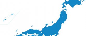
Japan is a unique country. In many ways, it is the people who make it unique. With an almost complete absence of mineral resources, in a climate not very favorable for agriculture, and having survived quite serious losses in World War II, the Japanese managed to preserve their national identity and create one of the most powerful economies in the world. It is also worth considering that Japan is one of the few highly developed countries located exclusively on islands. The Land of the Rising Sun is the fourth largest island nation in the world by area. In terms of territory size, it is second only to Indonesia, Madagascar and Papua New Guinea.
There are 6,852 islands belonging to Japan, all of which are part of the Japanese archipelago. People live on only 430 islands, but the vast majority of the population is concentrated on just the four largest islands. Each of them is worthy of a separate story.
Honshu
Geography and demographics
The island of Honshu is larger in size than all its neighbors in the archipelago. With an area of 228 thousand square meters. km, this island would not get lost even in the company of independent states. Honshu is only slightly smaller in area than Romania, but larger than Belarus, Uruguay or Syria. And in terms of population - more than 100 million people - Honshu would confidently enter the top twenty countries, ahead of Egypt, Vietnam and Germany. The largest island, which covers 60% of the country's territory, is home to 80% of the Japanese. The territory of Honshu is divided into 34 prefectures, which are combined into five regions.
Corresponds to the size of the territory and the variety of climatic conditions on Honshu. The southeastern part of the island, protected from cold winds by mountains (the legendary Fuji is also located on Honshu), blissfully enjoys a subtropical climate on the shores of the Pacific Ocean. In the north-west of the island the climate is quite sharply continental
Tokyo
The capital of Japan is located in the southeast of Honshu. The population of Tokyo is about 14 million people. It is known that people lived in Tokyo back in the Stone Age, but the history of the city dates back to the 12th century, when a fort called Edo was built here. Tokyo became the capital of the state in 1868. In the 20th century, Tokyo suffered serious damage twice - in the 20s due to an earthquake, and in the 40s due to American bombing. However, just 20 years after the end of World War II, Tokyo became the largest metropolis with a highly developed industry.
Tokyo's gross domestic product exceeds one and a half trillion dollars, but much of the city's output cannot be touched. The Japanese capital is, first of all, a financial and administrative center. Due to the desire of large companies to have offices in Tokyo, living in the city is very expensive. This applies to land, housing, and the overall cost of living. Tokyo has been recognized as the most expensive city in the world for many years in a row, only in recent years losing this dubious honor to Singapore, Hong Kong and Zurich.
Yokohama
Yokohama, with a population of 3.7 million, is the second city in Japan according to this criterion. It is interesting that the two most populated Japanese metropolises are de jure separated by only about 30 kilometers, although in practice Tokyo and Yokohama merge into one agglomeration.
The history of Yokohama is inextricably linked with the port. As soon as Japan opened to the outside world in the 19th century, a port appeared on the site of two fishing villages. He gave impetus to the development of the city. This development was not slowed down even by the earthquake of 1923, which destroyed 60,000 houses and claimed 20,000 lives. Yokohama has become a powerful transport hub where sea and railway routes intersect.
The city is home to many high-tech enterprises, as well as the offices of several of Japan's largest corporations. The main attraction of Yokohama is the suspension road bridge connecting the shores of Tokyo Bay.
Other areas of the archipelago
The island of Okinawa is located between Kyushu and Taiwan. It is the largest territory of the Ryukyu Archipelago. Area 1206.96 sq. km. Most of the population lives in the city of Naha. In total there are 800 thousand people here.
It is believed that there are more centenarians among local residents than in other provinces. This is a real fact. There are 34 centenarians per 100 thousand people, which is three times the Japanese average.
Part of the valuable territory is given over to a US military base. This issue causes constant controversy among citizens of the country who already suffer from a lack of space. The issue of the presence of military bases on Okinawa is a political issue, and no matter how actively the inhabitants of the island oppose the presence of Americans on their land, the Japanese government does not intend to resolve this issue in the near future.
Okinawa is the southernmost island of Japan.
Minamitori is the easternmost part of Japanese land. Its area is only 1.2 square meters. km. There is no permanent population here. However, the island is of great political importance for the entire country. Its location allows you to claim 428,875 sq. km of surrounding waters.
Hokkaido
Geography, demography and economics
The second largest island in the Japanese archipelago, Hokkaido, is the most un-Japanese of all the Japanese islands. It is located farthest north of all, so, according to the Japanese, it is terribly cold. It's no joke, the average annual temperature is only +8. Accordingly, the population density in Hokkaido is minimal by Japanese standards - 66 people per square kilometer (in Honshu, for example, this figure is 439).
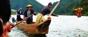
Hokkaido in Japan is about the same as Alaska in the USA. The people live quite poorly, but look down on other Japanese. Firstly, because of the climate, and secondly, because the majority of the population of Hokkaido outside the largest city of Sapporo is engaged in productive work, rather than being classified as white-collar workers. On the island they engage in agriculture and fishing, mine coal and iron ore, cut timber and produce paper.
Sapporo
The largest city and administrative center of Hokkaido is Sapporo. This city is best known throughout the world for hosting the 1972 Winter Olympics. Sapporo (pop. 2 million) is more like the rest of Japan. The majority of the city's population is employed in the service sector. Sapporo is the center of a large climatic resort and winter sports. The snow festival, held every year in early February, attracts millions of visitors.
Dispute over the Kuril Islands
The Kuril Islands are often called the Russian-Japanese islands, since over the past two centuries they have repeatedly changed their owner, and the dispute over the ownership of the southern part of the archipelago has not yet been resolved.
Kurile Islands
In February 1855, the Russian Empire and Japan drew up the Shimoda Treaty, which established the border between the states. According to this document, the Habomai group of islands, as well as Iturup, Sikotan and Kunashir, went to Japan. The rest of the Kuril Islands belonged to Russian territory. After the end of the Russo-Japanese War in 1905, the Portsmouth Treaty was signed, according to which Southern Sakhalin and the Kuril Islands became part of Japan in their entirety.
Kuril Islands on the map
During World War II, Japan used some of the Kuril Islands for military purposes. In particular, a powerful stronghold was formed on Matua, including anti-tank ditches, underground communications, bunkers and docks. Nowadays, the issue of creating a base for the forces of the Russian Pacific Fleet on the territory of the former Japanese island has been raised more than once due to its favorable strategic location.
View from space of the Southern Kuril Islands
As a result of World War II, Japan was forced to sign an agreement according to which it renounced its claims to the Kuril Islands and South Sakhalin, which by that time had already been occupied by Soviet troops. At the same time, the official position of Japan is that the islands of Iturup, Sikotan, Kunashir and the Habomai group are not part of the Kuril Islands, therefore they are not subject to the treaty. The Russian government does not agree with this position, considering the listed islands to be part of the Russian Federation as the legal successor of the USSR. As a result of the long-standing dispute over the Kuril archipelago, serious tension continues to exist in the political field between Russia and Japan.
Kyushu
Geography, demography and economics
Some historians believe that Japanese civilization began on the island of Kyushu. The relief of the third largest Japanese island is highly rugged. There are no too high mountains, but hardly a quarter of the territory of Kyushu can be classified as plains.
The climate on the southernmost of the large Japanese islands is subtropical and mild. Kyushu has many rivers and underground springs, and the island is rich in diverse vegetation.
More than 12 million people live on the island. With an island area of 40.5 thousand square meters. km, the population density is almost 300 people per square meter. km.
Production in Kyushu is quite clearly divided geographically - industry is concentrated in the north of the island, agriculture in the south. Chemistry, metallurgy and metalworking are well developed. Farmers grow industrial crops, rice and raise livestock.
Fukuoka
The city of Fukuoka was a port connecting Japan to the continent back in the first millennium AD. Accordingly, the city developed as a commercial and cultural center. In the middle of the last century, Fukuoka also became an industrial center. These same industries are developed in the city today.
In addition, the city with a population of 1.5 million people has enterprises producing computers and telecommunications equipment, mechanical engineering products and electrical goods. Fukuoka is the junction of almost all the island's railways and roads.
How not to believe legends?
The Japanese islands are of volcanic origin, from a scientific point of view. They continue to form today. The last case of the “birth” of the earth occurred in November 2013. Near the island of Ogasawara in the Bonin archipelago, a piece of land was formed as a result of a volcanic eruption. After several months, he connected with the island of Nishinoshima.
Local residents are pleased with this replenishment; the island country constantly feels a lack of territory. Volcanic eruptions are a dangerous event, but they provide new land for life, which Japan so badly needs.
Shikoku
Geography and demographics
Shikoku Island boasts the title of the smallest of the large Japanese islands. The mild climate and developed river network favor the development of agriculture, so the island is underdeveloped industrially. Industry, which is based on metallurgy and shipbuilding, is concentrated in the north of Shikoku. In the south, where two harvests can be harvested a year, people are mainly engaged in agriculture.
On an island with an area of 18.8 thousand square meters. km. 4 million people live. The population is gradually aging and shrinking - young people are leaving Shikoku, moving to more developed regions of Japan. Even the construction of bridges between Shikoku and the island of Honshu does not help the outflow of population.
Matsuyama
Matsuyama is not only the largest city on the island of Shikoku. This is the real capital of haiku. Six times a year, the city holds a competition for the best traditional Japanese poetry. Every year, up to 50,000 poetic works participate in competitions.
Matsuyama is another of the oldest cities in Japan, which became part of the state back in the 4th century AD. After a series of historical upheavals, the city became the center of the prefecture, which sharply increased its status.
Nowadays, enterprises in the paper, textile and engineering industries, as well as petrochemical production, operate in Matsuyama. The city generates a lot of income from tourists visiting historical castles, temples, and pilgrims - 8 Matsuyama temples are included in the famous Buddhist pilgrimage route 140 kilometers long.
Youth elixir
0
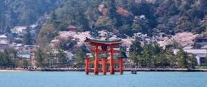
The Okinawa group of islands in the East China Sea and part of the Ryukyu Arc are famous for their beautiful beaches, limestone caves and coral reefs. But the most interesting thing is that the islanders live longer here than anywhere else in the world. They attribute this to diet (low-fat, low-salt foods such as fish, tofu and seaweed), low stress levels and spirituality.
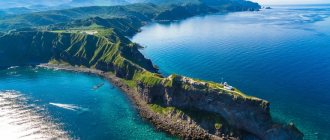
Sado
The rocky coves, cliffs and emerald waters along the shores of Sado Island make for a stunning spot for kayaking or diving. At the same time, the coastline is no less impressive than the cedar forests in the interior of the island.
Photo: (CC BY-SA 3.0)
Photo: (CC BY-SA 3.0)
Photo: (CC BY-SA 3.0)
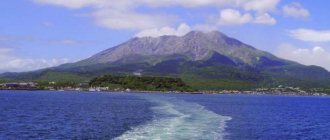
Rishiri
Mount Rishiri, a dormant volcano and symbol of this remote northern island, is breathtaking when the summit is blanketed with snow in winter. But it looks even more impressive in the summer, when the alpine meadows bloom here.
Photo: (CC BY-SA 3.0)
Photo: (CC BY-SA 4.0)
Photo: (CC BY 3.0)
Rebun
Walk around the mountainous island of Rebun to see 300 species of alpine flowers and admire the neighboring island of Rishiri, but don't miss the scenic walk along the steep southern coast!
Photo: (CC BY 2.0)
Photo: nachans / flickr (CC BY 2.0)
Photo: (CC BY-SA 4.0)
Ishigaki
Ishigaki Island, part of the Yaeyama group of islands, is a thriving urban center. However, the island's secluded coves, white sand beaches and pineapple plantations create the feeling of a true tropical paradise.
Photo: auntmasako / pixabay (Pixabay License)
Photo: (CC BY-SA 3.0)
Photo: Nicholas Wang / flickr (CC BY-SA 2.0)