Japan is a unique country. In many ways, it is the people who make it unique. With an almost complete absence of mineral resources, in a climate not very favorable for agriculture, and having survived quite serious losses in World War II, the Japanese managed to preserve their national identity and create one of the most powerful economies in the world. It is also worth considering that Japan is one of the few highly developed countries located exclusively on islands. The Land of the Rising Sun is the fourth largest island nation in the world by area. In terms of territory size, it is second only to Indonesia, Madagascar and Papua New Guinea.
There are 6,852 islands belonging to Japan, all of which are part of the Japanese archipelago. People live on only 430 islands, but the vast majority of the population is concentrated on just the four largest islands. Each of them is worthy of a separate story.
Honshu
Geography and demographics
The island of Honshu is larger in size than all its neighbors in the archipelago. With an area of 228 thousand square meters. km, this island would not get lost even in the company of independent states. Honshu is only slightly smaller in area than Romania, but larger than Belarus, Uruguay or Syria. And in terms of population - more than 100 million people - Honshu would confidently enter the top twenty countries, ahead of Egypt, Vietnam and Germany. The largest island, which covers 60% of the country's territory, is home to 80% of the Japanese. The territory of Honshu is divided into 34 prefectures, which are combined into five regions.
Corresponds to the size of the territory and the variety of climatic conditions on Honshu. The southeastern part of the island, protected from cold winds by mountains (the legendary Fuji is also located on Honshu), blissfully enjoys a subtropical climate on the shores of the Pacific Ocean. In the north-west of the island the climate is quite sharply continental
Tokyo
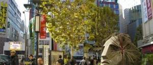
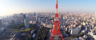
The capital of Japan is located in the southeast of Honshu. The population of Tokyo is about 14 million people. It is known that people lived in Tokyo back in the Stone Age, but the history of the city dates back to the 12th century, when a fort called Edo was built here. Tokyo became the capital of the state in 1868. In the 20th century, Tokyo suffered serious damage twice - in the 20s due to an earthquake, and in the 40s due to American bombing. However, just 20 years after the end of World War II, Tokyo became the largest metropolis with a highly developed industry.
Tokyo's gross domestic product exceeds one and a half trillion dollars, but much of the city's output cannot be touched. The Japanese capital is, first of all, a financial and administrative center. Due to the desire of large companies to have offices in Tokyo, living in the city is very expensive. This applies to land, housing, and the overall cost of living. Tokyo has been recognized as the most expensive city in the world for many years in a row, only in recent years losing this dubious honor to Singapore, Hong Kong and Zurich.
Yokohama
Yokohama, with a population of 3.7 million, is the second city in Japan according to this criterion. It is interesting that the two most populated Japanese metropolises are de jure separated by only about 30 kilometers, although in practice Tokyo and Yokohama merge into one agglomeration.
The history of Yokohama is inextricably linked with the port. As soon as Japan opened to the outside world in the 19th century, a port appeared on the site of two fishing villages. He gave impetus to the development of the city. This development was not slowed down even by the earthquake of 1923, which destroyed 60,000 houses and claimed 20,000 lives. Yokohama has become a powerful transport hub where sea and railway routes intersect.
The city is home to many high-tech enterprises, as well as the offices of several of Japan's largest corporations. The main attraction of Yokohama is the suspension road bridge connecting the shores of Tokyo Bay.
Islands of the Inland Sea of Japan
There are about 3 thousand islands in the Inland Sea of Japan, the most important of which are:
- Awaji, with a size of 592 km2, is considered to be the largest landmass in the above-mentioned sea. Connected to other parts of the archipelago by bridges. Divided into 3 city cantons. The main activity of the population is agriculture.
- Sedoshima. It is administratively divided into 2 municipal districts, which have been assigned village status. Due to the fact that the natural Kankakey Gorge is located here, the area is popular among tourists. The island became famous as the place where the Japanese first began cultivating olives. Currently there is an olive grove with a windmill. In 2010, Sedoshima was included in one of the locations where the festival of international creativity operates. There is also a pilgrimage route past 88 island shrines.
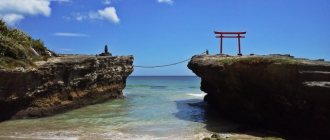
- Itsukushima has a mountainous terrain and has an area of 30.4 km2. Population of about 2 thousand people. lives in small settlements with simple buildings. The highest peak of the landmass is Mt. Misen (535 m), which can be reached by cable car. Itsukushima has picturesque nature all year round and cutting down trees is prohibited. This land is considered sacred; there are a large number of temples on it, one of them is included in the UNESCO list.
The island and the adjacent sea form a national park. There is a ferry connection with other parts of the archipelago.
Hokkaido
Geography, demography and economics
The second largest island in the Japanese archipelago, Hokkaido, is the most un-Japanese of all the Japanese islands. It is located farthest north of all, so, according to the Japanese, it is terribly cold. It's no joke, the average annual temperature is only +8. Accordingly, the population density in Hokkaido is minimal by Japanese standards - 66 people per square kilometer (in Honshu, for example, this figure is 439).
Hokkaido in Japan is about the same as Alaska in the USA. The people live quite poorly, but look down on other Japanese. Firstly, because of the climate, and secondly, because the majority of the population of Hokkaido outside the largest city of Sapporo is engaged in productive work, rather than being classified as white-collar workers. On the island they engage in agriculture and fishing, mine coal and iron ore, cut timber and produce paper.
Sapporo
The largest city and administrative center of Hokkaido is Sapporo. This city is best known throughout the world for hosting the 1972 Winter Olympics. Sapporo (pop. 2 million) is more like the rest of Japan. The majority of the city's population is employed in the service sector. Sapporo is the center of a large climatic resort and winter sports. The snow festival, held every year in early February, attracts millions of visitors.
Features of the geographical location
The Japanese islands have a unique location on the world map, because they stretch on a layered volcanic archipelago with mountainous terrain. Most of them are of mountainous origin, many of them volcanic. The highest point of the country is Fuji (3775 m), which is considered a sacred place.
Japan is located at the junction of tectonic plates, so volcanoes and earthquakes are common occurrences. despite this, there are no large reserves of minerals here.
The Japanese islands on the world map, like the countries of the DPRK, the People's Republic of China, the Republic of Korea, and Taiwan, belong to East Asia.
The Japanese climate is moderate, there are clearly demarcated 4 seasons. But the temperature indicators of the north and south differ greatly, which is due to winds. If we divide the island space into climatic zones, then they can be divided into 6 zones. The rainy season involves large amounts of precipitation and there is a possibility of typhoons.
Kyushu
Geography, demography and economics
Some historians believe that Japanese civilization began on the island of Kyushu. The relief of the third largest Japanese island is highly rugged. There are no too high mountains, but hardly a quarter of the territory of Kyushu can be classified as plains.
The climate on the southernmost of the large Japanese islands is subtropical and mild. Kyushu has many rivers and underground springs, and the island is rich in diverse vegetation.
More than 12 million people live on the island. With an island area of 40.5 thousand square meters. km, the population density is almost 300 people per square meter. km.
Production in Kyushu is quite clearly divided geographically - industry is concentrated in the north of the island, agriculture in the south. Chemistry, metallurgy and metalworking are well developed. Farmers grow industrial crops, rice and raise livestock.
Fukuoka
The city of Fukuoka was a port connecting Japan to the continent back in the first millennium AD. Accordingly, the city developed as a commercial and cultural center. In the middle of the last century, Fukuoka also became an industrial center. These same industries are developed in the city today.
In addition, the city with a population of 1.5 million people has enterprises producing computers and telecommunications equipment, mechanical engineering products and electrical goods. Fukuoka is the junction of almost all the island's railways and roads.
General information about the country
Japan is an Asian island state, which is located on an archipelago consisting of more than 6.5 thousand islands. The four largest land areas occupy 97% of the entire territory of the state. About 98% of the residents are Japanese.
| Categories | Number, persons |
| Total population | 127 million |
| Population of the capital and surrounding prefectures | 38 million |
The capital of the land of the rising sun is Tokyo. Japan is considered a constitutional monarchy, has a democratic system with unitary decentralization and occupies a leading position (3rd place) in terms of nominal GDP. The exchange rate is not regulated by the state; it is set as a result of free trading. It has a high standard of living and longevity.
The state is divided into 47 prefectures, the largest of which is Fr.
Hokkaido. Inside, the divided territories are divided into districts and districts, which have local governments. The main official language is Japanese, the traditional religion is Shintoism and, to a lesser extent, Buddhism.
Ports are of great economic importance; the 6 largest of them specialize in international transport, trade and passenger flights.
Shikoku
Geography and demographics
Shikoku Island boasts the title of the smallest of the large Japanese islands. The mild climate and developed river network favor the development of agriculture, so the island is underdeveloped industrially. Industry, which is based on metallurgy and shipbuilding, is concentrated in the north of Shikoku. In the south, where two harvests can be harvested a year, people are mainly engaged in agriculture.
On an island with an area of 18.8 thousand square meters. km. 4 million people live. The population is gradually aging and shrinking - young people are leaving Shikoku, moving to more developed regions of Japan. Even the construction of bridges between Shikoku and the island of Honshu does not help the outflow of population.
Matsuyama
Matsuyama is not only the largest city on the island of Shikoku. This is the real capital of haiku. Six times a year, the city holds a competition for the best traditional Japanese poetry. Every year, up to 50,000 poetic works participate in competitions.
Matsuyama is another of the oldest cities in Japan, which became part of the state back in the 4th century AD. After a series of historical upheavals, the city became the center of the prefecture, which sharply increased its status.
Nowadays, enterprises in the paper, textile and engineering industries, as well as petrochemical production, operate in Matsuyama. The city generates a lot of income from tourists visiting historical castles, temples, and pilgrims - 8 Matsuyama temples are included in the famous Buddhist pilgrimage route 140 kilometers long.
Where is Japan on the world map
The Japanese islands on the world map are located in eastern Asia and are washed by Pacific waters. The island state occupies the space from the East China to the Sea of Okhotsk, and its southern part reaches the island. Taiwan. The entire island group consists of 4 large and about 7 thousand small land areas.
The Land of the Rising Sun has no land borders, and the total kilometer of the coastline is 29.9 thousand km. Japan's economic zone extends 200 nautical miles into the ocean, and its territorial space extends up to 12 miles.
Korea Strait Islands
Main islands of the Korea Strait:
Tsushima . It has a territory of 696 km2 with a population of 34.5 thousand people. Until 1900, Tsushima was a single island, but now it is actually divided by the Aso Canal into 2 large sections of land, connected to one another by a bridge. The northern territory is called Kaminoshima, and the southern territory is marked as Shimonoshima.
The Tsushima naval battle took place in this area in 1905. The production and processing of seafood and fish, as well as the tourism industry, are developed here. In 2004, the city of Tsushima was formed through the merger of 7 villages.
Iki is included in Nagasaki Prefecture. The main settlement on the island bears the same name. It is of volcanic origin and has an area of 139 km2. Hot springs have been found on this land. Iki has mild climatic conditions, which is due to the Kuroshio Current flowing nearby.
On about. Okinoshima, with an area of 0.97 km2, is home to 1 person, who is appointed as the caretaker of the temple. The sanctuary was erected in the southwestern island zone. The local population considers this place sacred. In 2021 Fr. Okinoshima is included in the UNESCO heritage list.
Islands of the East China Sea
The Japanese islands on the world map are located in the East China Sea, the most significant of which are:
- Hirado, with a territory of 163 km2, is divided by a strait with the city of the same name. A bridge connects them. The main occupation of local residents is agriculture (cultivation of tangerines, cultivation of pearls and breeding of beef cows).
- Goto . An island group extending in the west of the archipelago. It consists of 200 islands of different sizes. In medieval times it was a habitat for pirates. Now Christianity dominates here, fishing and tourism flourish.
- Hashima . It was settled in 1810 after the discovery of coal on it. In the 30s XX century the land turned into an industrial center with the presence of mines and military enterprises. For some time this place was considered the most densely populated on earth. After the decline in production in 1974, the mines stopped working and all residents left the city.
Plot about the ghost island of Hashima:
https://www.youtube.com/watch?v=XPYEDK0Y2NA
In 2015 Fr. Hashima is included in the list of World Heritage Sites. Now tourists are allowed to visit an area specially equipped for safe viewing.
Beach and swimming season
The climate of the Land of the Rising Sun is moderate, with clear distinctions between seasons and rainy seasons. Vacationers begin to visit the beaches in the third ten days of May, when the atmosphere warms up to +25 0 C. Scorching heat appears in Japanese resorts in mid-summer and continues until the beginning of September.
The beach season begins here at the same time as the wet season, and June is called the period of “plum rain” by locals.
The optimal time for swimming and beach holidays is considered to be the period from the last days of August to the second ten days of October, when thermometers show an air temperature of +270 C, and the water warms up to 240 C.
Beach resorts in Japan
The climate of the state varies from low temperatures in the north to subtropics in the southern region . The weather is also determined by seasonal winds blowing from the mainland in the cold season, and in the opposite direction in the summer.
Japan is divided into 6 climate bands:
- Hokkaido has long winters, cool summers and is considered an area of low temperatures.
- The Sea of Japan is characterized by heavy snowfalls in the winter season, and when it is warm, extremely high micro-temperature regimes sometimes occur.
- The central highlands are dominated by the usual island microclimate with a large temperature difference, both at different times of the year and throughout the day.
- In the Inland Sea of Japan area, weather conditions are moderate due to the nearby wind-blocking mountains.
- The Pacific Ocean experiences harsh winters with occasional snowfall and humid and sultry summers.
- The islands in the south and west of the continent are characterized by subtropics. It is warm here in winter and quite hot in summer. Rainfall is high, leading to a rainy season and the occurrence of typhoons.
The best resorts in Japan:
A. Okinawa is suitable for diving tourists. The Kuroshio Current flows in this area, which diversifies the world of underwater habitats. The swimming season lasts from May to October.
Kamakura . Popular because it is close to Tokyo. It is home to Buddhist shrines, excellent beaches and picturesque landscapes. Thanks to its mild climate, it is suitable for a beach holiday at any time of the year. The metropolis is surrounded on 3 sides by forested mountains.
In Miyazaki there is an artificially created Shigaya Beach. It offers sun and water baths from May to November. Beach treatments can be combined with therapy in hot springs (onsen).
The coastal strip of Shirahama is distinguished by white quartz sand brought from Australia. The resort area is picturesque and landscaped.
A large number of Japanese islands, which can be easily found on the world map, form an archipelago. If you want to plunge into the mysteries of Eastern culture and feel the rhythm of modern megacities, it is worth visiting this strikingly unique and enchanting island state.
Article design: E. Chaikina
Islands on the outer side of the archipelago
List of main islands located on the outer side of the archipelago:
- Enoshima is a small landmass of volcanic formation. It is part of the Fujisawa administrative district, connected to the mainland by a bridge. Here in 1964 a sports harbor was built for the Olympics. The 2021 regatta is planned to be held in Enoshima.
- Izu is a volcanic island chain that is part of Tokyo. Located at a distance of 100-350 km from the Japanese capital. These scenic spots are included in the national park. Tokyo residents love to relax here, and people involved in water sports also spend time here.
- Izuoisma (area 91 km2) is the largest in the Izu archipelago group. There is a volcano called Mihara (764 m), which is popular among tourists. It is connected to the capital of the country by ferry and air routes.
- Toshima is a volcanic landmass that is part of Tokyo Prefecture and has 304 inhabitants. The island's territory is 4.1 km2. On 80% of the land there are specific forests, which are colored red during flowering. The village of the same name is the local government unit in Toshima.
The fishing and tourism industries are developed here, as well as farms.
Islands in lakes
Islands located in lakes:
- O. Chibukushima is located on the largest lake Biwa. The coastal length is 2 km, and the area is 0.14 km2. It is formed predominantly from granite rocks. In the Middle Ages, rebellious subjects were sent to this piece of land.
- O. Dejima was created artificially in Nagasaki Bay. Initially, it was used as a warehouse for Portuguese traders, and at a later time served as a Dutch trading port.
- Odaiba is an artificial piece of land in the Tokyo Strait, which was intended to house military fortifications. In the post-war period, port buildings and warehouses were built here.
At the moment, offices and shopping centers are rising on this land, as well as a railway station.
Ryukyu Islands
On the world map there are Japanese islands included in the group (98 pieces). called Ryukyu:
Okinawa has an area of 1207 km2, and ranks 5th in size after 4 land masses. In the north there is a low-mountain massif of volcanic type, the area is wooded and has a dense river network. Acerola is cultivated in the agricultural industry.
Limestone mining for cement production has been developed. The southern edge of Okinawa is composed of limestone rocks and is predominantly flat. Climatic conditions are typical for the moderately humid subtropical zone. In summer, temperatures reach 32-330C, and typhoons often occur.
winter is warm - the temperature never drops below 90C. The martial art of Okinawa-te, which is the founder of many styles of karate, originated in Okinawa.
Sakishima consists of an island group in the western Pacific Ocean, which in turn are divided into 3 subgroups (Miyako, Yaeyama, Senkaku). The islands stretch in a chain about 280 km long and extend over an area of 817 km2. The population of Sakishima is 108 thousand people.
These lands are contested by the People's Republic of China.
Borodino - consists of 3 islands (Kita-Daito, Oki-Daito and Minami-Daito) on which about 2.1 thousand people live. It got its name thanks to a Russian navigator who sailed past on the ship Borodino. The first settlements appeared at the end of the 19th century. There is a thriving fishing industry and a distillery producing rum.
Pacific Islands
There are Japanese islands in the Pacific Ocean, the most important of which are:
Bonin (Nampo) is an island group of 40 islets, which is divided into several subgroups: Mukojima, Hahajima, Chichijima and others. According to various sources, their area is 84-104 km2. These areas are characterized by active volcanism.
The climate zone of Bonin is classified as oceanic subtropical. Now about 2.4 thousand people live here.
Kazan consists of 3 landmasses (Ioto, Northern and Southern Ioto) and appears as an arc formed from extinct volcanoes. The Japanese army, numbering about 400 people, is based on Ioto. The remaining 2 islands are deserted.
Okinotori - consisting of 3 small islands and belongs to the coral atolls. Their total size is 8.5 km2, and the territory occupied by the reef is 7.8 km2.
Minamitori is an isolated piece of land with an area of 1.2 km2. It is the easternmost point of the state and a strategic object, because it gives Japan the right to claim 428 thousand km2 in coastal waters. In 2012, Japanese scientists discovered deposits of rare earth metals in the island zone, estimated together with yttrium at 6.8 million tons.
This amount will be enough for the needs of Japan for 200 years to come.
Islands of the Sea of Japan
There are about 3 thousand large and small islands in the Sea of Japan, most of them belong to the Japanese archipelago.
In addition to the 4 main islands, the following names can be distinguished:
Rishiri, with an area of 182 km2, is of volcanic origin. On the map it looks like a regular circle, but in fact its configuration depicts a volcanic cone lowered into the sea. Tourists visit this land to climb to the top of Rishiri-san (1721 m).
Together with the adjacent island. Rebun in 1974 it was included in the national park. The two most important areas of employment are fishing and tourism. Local residents traditionally prepare seaweed. There is an airport and 3 ferries operate daily.
Rishiri has a well-developed municipal transport structure; a bicycle path covers half of the island's territory.
Sado is the 8th largest island in Japan. Its entire area (855 km2) is occupied by a city of the same name, with a population of 65 thousand people. The terrain is divided into 3 zones: hilly, mountainous and flat. Near the highest peak of Kimpoku (1172 m) there is a national park. In former times, political prisoners were sent to this land.
In the 16th century Gold deposits were found in Sado.
Oki is an island group consisting of 4 large landmasses and 18 small islands located next to them. They were formed during the Paleolithic era after a volcanic eruption. Famous for being a place of exile for political swindlers. In 2004, Saiko and several villages formed the city of Okinoshima. There is an airport here.