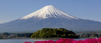
Fuji is a mountain located on the island of Honshu in Japan. It has the shape of a cone and is part of the “Japanese Alps” system. Mount Fuji is a famous tourist attraction listed as a UNESCO World Heritage Site. Pilgrims professing Buddhism and Shintoism also regularly go here. The top of Mount Fuji in the photo is usually covered with snow, with the exception of the last summer months.
Many people wonder: Is Fuji a mountain or a volcano? The answer to this popular question: it is a mountainous volcano of the layered type.
Mount Fuji is a symbol of Japan, it is also called sacred (Fujisan). A Shinto temple was erected on its slopes, a weather station and a post office were equipped. Mount Fuji is the highest point in Japan, a status earned by its Kengamine Peak.
The height of Mount Fuji is 3,776 meters.
In fact, the common name "Mount Fuji-yama" is considered redundant and therefore incorrect, since "yama" is translated from Japanese as "mountain". The name "Mount Fuji" is adopted. There is no exact explanation of where the word “Fuji” came from and what it means; there are only various theories.
There is another interesting fact about the mountain in Japan. Many people don’t think about whose ownership is Mount Fuji. In fact, it is the private property of the Great Hongu Sengen Shrine, this Shinto shrine received Fuji from the shogun, according to a deed of 1609.
© Tatiana Dudarenko
Images in culture
Fuji has inspired many people to use her image in their work. Since ancient times, the Japanese have composed various legends about the mountain, attributing magical properties to it. You can see Mount Fuji in paintings, films and literature. Modern researchers believe that artists of past centuries romanticized and idealized the mountain, depicting it not as it really is. Sometimes its name is used only as a metaphor and a vivid image, for example, the book “How to Move Mount Fuji” by W. Poundstone is dedicated not to the Fuji volcano, but to the method of searching for talent when hiring.
Mount Fuji and Pelevin
In 2021, the book “Secret Views of Mount Fuji” by the modern Russian writer Viktor Pelevin was published. The short novel is also called “The Mystery of Mount Fuji”, it is about the search for happiness, there is a satire on feminism, startups and modern society. In the story, the word "Fuji" is used in the name of a startup whose author helps clients regain the joy of life, in the process he uses various Buddhist practices, modified for today's oligarchs. Written in the spirit of postmodernism, Victor Pelevin's novel about Mount Fuji is filled with a play of meanings and references to various cultural phenomena. According to reviews, after reading Pelevin, the views of Mount Fuji open up from a new side - it turns out that the secret view is very close when you don’t see it, but whether it’s worth climbing the mountain and what it will give - remains a big question. The title of the book also refers to the work of Hokusai and his series of prints “Thirty-six Views of Mount Fuji”.
© Tatiana Dudarenko
Mount Fuji and Hokusai
Some of the most famous images of the mountain are Japanese ukiyo-e prints. Katsushika Hokusai, a famous Japanese artist, depicted the sacred mountain in many prints. Hokusai depicted Mount Fuji in all the engravings in several series:
- "36 Views of Mount Fuji" . Everywhere Fujisan is visible from Tokyo; subsequently, 10 additional works were made, where the mountain is drawn from the reverse side. This series also includes the famous image of a wave, against which you can see a mountain, “The Great Wave off Kanagawa.” Hokusai's views of Mount Fuji were repeated by the artist Hiroshige in a series of 36 works of the same name.
- "One Hundred Views of Mount Fuji" . These are three albums that differ from the first series of works in color design - the engravings are made in two colors: black and gray.
© Evgenia Fatykhova
Relief of Japan
The coastline of Japan is highly rugged; there are a large number of bays and sea bays. A characteristic feature of the local terrain is the predominance of mountains, constituting 71% of the entire territory of the country. The number of plains and lowlands is small; these are small coastal areas near the sea or in river valleys, bordered by mountain peaks.
(Detailed relief map of Japan)
The relief of Japan is the result of mountain building processes that continue to this day in the seismically unstable Pacific geosynclinal region. Every year thousands of earthquakes of varying amplitude are recorded here; if an earthquake occurs at the bottom of the sea or ocean, the danger of huge tidal waves and tsunamis rising increases; their destructive power can cause significant harm to both people and their property.
Climbing Mount Fuji
The mountain is located within the Fuji-Hakone-Izu National Park. For climbing Mount Fuji, the recommended period is from July to August, when the tourist infrastructure is equipped here: rescue centers and mountain hotels for recreation operate, food and drinks are sold. It is during these months that there is no snow at the top, so this time is preferable and safer for climbing Mount Fuji. Rain is still possible at the beginning of July; it is better to plan your trip for the second part of the month. However, tourists climb the mountain even in winter.
There are 10 levels (stations) on the mountain, and 4 different routes start from different points near the foot. There are also 4 roads leading from level No. 5 to the very top:
- Yoshida (yellow route) 13.8 km long. Starting at 2,305 m, the climb to an altitude of 3,710 m takes about 6.5 hours. This route to the Japanese Mount Fuji is most often chosen by those arriving from Tokyo.
- Subashiri (red) is 12.9 km long. From an altitude of 2,000 m it leads through the forest, climbing Mount Fuji (3,710 m) takes 7 hours, descending through a sandy section.
- Fujinomiya (blue) is 8.7 km long. The most difficult and steep route leads to an altitude of 3,720 m. The road up takes about 6 hours.
- Gotemba (green) 17.4 km. It is chosen by experienced mountain travelers. The climb to the sacred Mount Fuji takes approximately 9 hours.
© pexels.com
The descent usually takes about 4 hours. Buses travel along the Subaru Line toll road from Lake Kawaguchiko to the station at Level 5 on Mount Fuji. This place has a parking area and restaurants, and most of the tourist routes pass here. You can also drive your own car along the toll road.
Traveling to Mount Fuji does not require special preparation; you should be prepared for some physical activity, take warm clothes, gloves, and a raincoat with you. It is not recommended to plan a visit to Mount Fuji on weekends and holidays when large numbers of people travel here. Typically, you set aside two days for the trip to acclimate to the altitude. Overnight stays are organized only in mountain hotels; advance reservations are required. There are paid toilets on the slopes of Mount Fuji; you should take some change with you. It is also necessary to prepare garbage bags, since the conservation of the nature of the national park is strictly monitored.
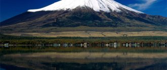
In some reviews, travelers write that the best view of Volcano Fuji opens from the foot, when the entire mountain is visible, and the views from the top are not very impressive. Therefore, they consider the effort spent on climbing to be in vain and recommend enjoying the mountain from below.
Panoramic view of Mount Fuji in Japan:
Geology
There is no consensus in the scientific community about what the cluster of Japanese islands is. Some scientists view them as a submerged microcontinent, since Japan is characterized by increased thickness of the earth's crust. The archipelago is located above a specific zone of thrust of the island crust onto the oceanic crust, which is part of the Pacific Ring of Fire. The core axis of Hokkaido is formed by sedimentary-volcanogenic processes. In the west there are additionally Upper Cretaceous and Cenozoic deposits. The northeast of Honshu, in the structure of which the main role is played by Paleozoic deposits represented by terrigenous strata, is separated from its southwestern part by a meridional graben. All these deposits are embedded in folds. The western coast of Honshu is formed by green Neogene tuffs. In the southwestern part of Japan there is a zonal structure with a general rejuvenation of zones. The most ancient Precambrian rocks make up the Hida zone. In the southeast of the country, volcanic-sedimentary deposits of the Paleozoic are developed, which have undergone folding deformation. The chalk belt extends along the border with the outer zones.
Almost every day, earthquakes occur on one of the many islands, which indicates the incompleteness of the mountain building process.
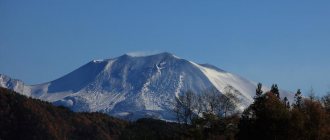
Eruption of Mount Fuji
Many people are interested in whether Mount Fuji is active or extinct? It is active, but is now considered weakly active. Mount Fuji last erupted in the first decade of the 18th century, during the Edo period. It was one of the most powerful explosions, as a result of which new craters were formed on Mount Fuji, and several cities, including Tokyo, were covered with a layer of ash. In recent years, there have been periodic reports of a possible eruption of Mount Fuji. It is difficult to predict its behavior, since the volcano is considered young.
The age of Mount Fuji is estimated at several thousand years. It began to form approximately 11–8,000 years ago. The mountain arose from the erupted lava of other ancient volcanoes.
Hydrography
The territory of the country is covered by an extensive network of large and small mountain rivers. The longest river in Japan is the Shinano, located on the island of Honshu. It is born in the Japanese Alps and flows into the Sea of Japan. There are also two other large waterways: Kitakami (294 km), Tone (322 km), Kiso (229 km) and Tenryu (213 km). Tesho and Ishikari are quite long, 268 km long, located on the island. Hokkaido. There are many small freshwater lakes on the islands. At the same time, near Kyoto there is one of the most ancient lakes, Biwa, which has historical and cultural value. Its average depth is 41 km. The second largest lake in Japan (220 km?) is Kasumigaura. It is located in the east of the island of Honshu. Currently, Lake Kasumigaura is used for fishing, irrigation, and tourism. A special feature of Japan is the presence of numerous crater lakes. The largest of them is Towada on the island of Honshu. Located at an altitude of 400 m above sea level.
Forest
At the foot of Mount Fuji there is an area with the sad name “Suicide Forest” (“Aokigahara”). According to legends, demons and ghosts live here. Over time, the forest near Mount Fuji has become a place for suicide; it ranks second in the world ranking of places to commit suicide. This is a forest of various coniferous trees and boxwood, grown on the ground of volcanic rock. They say that it is unusually quiet and windless here. You can walk along it when climbing Mount Fuji from the northern slope, or just come for a picnic.
Forest near the mountain, © Evgenia Fatykhova
Flora and fauna
Japan's flora is rich and varied due to high humidity and a wide range of climatic conditions. It has more than 17 thousand species of plants, the most famous of which are sakura and plum. More than half of the territory is occupied by forests. Coniferous forests predominate on the northern islands. Moreover, in the north of Hokkaido, spruce and fir trees predominate, and in the south, cypress and pine trees predominate. The heart of the island is occupied by broadleaf forests of beech, maple and oak. Cypress and pine trees grow well in the north of Honshu. In the central part of the island, birch, willow, and walnut trees grow, but in the south they are replaced by evergreen forests of Japanese magnolia and jagged oak, which also spread to the north of the islands of Kyushu and Shikoku. Here you can also find bamboo and banyan trees, as well as laurel forests. Further south, tropical and subtropical forests extend across the archipelago. They are characterized by the presence of bananas, palms, tree ferns and ficus. In some places on the islands you can find thousand-year-old Japanese cryptomerias up to 50 meters high. The central mountain range of Hokkaido Island is characterized by thickets of rhododendrons and heather above the forest line, which then give way to alpine meadows. In spring, azaleas and peonies bloom everywhere, and in November, chrysanthemums bloom.
The fauna is less diverse, which is due to the isolation of the islands. For the same reason, there are many endemics here. Thus, some species of woodpeckers, pheasants, dragonflies, crabs, sharks, snakes, salamanders and marine mammals are not found anywhere else. In the north of the country, the forests are inhabited by brown bears, short-legged wolves, foxes, weasels, and mountain antelopes. Hares, martens, squirrels and flying squirrels are common. Among the birds you can often see swallows, cuckoos, sparrows, thrushes, and woodpeckers. Ducks, swans and cranes live on the lakes, and albatrosses and snipes live on the sea coasts.