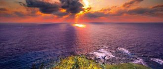
Japan is a country that is located on islands, and even mountainous ones, which becomes an ideal condition for the formation of volcanoes. Therefore, it is not surprising that throughout their history, the Japanese people worshiped this natural phenomenon and cajoled it in every possible way so that the volcano would not wipe out cities and towns. Today, the mountains that erupt lava are the object of tourist attention and serve as a symbol of the country. We have compiled a rating of the most beautiful “breathing” peaks, and the legendary Mount Fuji is in first place.
Asama
Mount Asama and the active volcano of the same name are located on the largest island of Japan - Honshu. The last time lava erupted from the mouth of this volcano was in 1783 and thereby claimed the lives of thousands of people. In 2009, the mountain simply decided to “breathe” and showered all nearby villages with ashes, and echoes of this phenomenon were noticeable even in Tokyo. Currently, the mountainside is used as a ski resort, and locals and tourists like to bask and relax in the nearby hot springs.
Fuji eruptions
In the entire history of monitoring the volcano since 781 AD. e., seismologists recorded twelve eruptions of Fuji, the strongest of which occurred at the beginning of the 18th century. Three new craters were formed on the eastern side of the mountain, and volcanic ash covered the streets of Tokyo, located almost a hundred kilometers from Fuji, with a 15-meter layer. As of 2015, this is the last eruption, so it is currently considered an active, low eruptive volcano.
Not everyone agrees with this definition. Recently, scientists have been talking more and more about the awakening of Fuji: special instruments have recorded that the pressure in the magma basin of the volcano as of 2015 is much greater than it was during its last eruption. An important role in this was played by the magnitude nine earthquake of 2011, which caused a huge tsunami that flooded a number of coastal Japanese cities.
An approaching earthquake that could trigger a volcanic eruption is also indicated by a rise in the water level in Lake Sai, one of the Five Lakes of the volcano, numerous steam emissions from the vent and an increase in the number of volcanic earthquakes. In 2012, geologists discovered that a fault line about 35 km wide runs under Fuji, along which an earthquake could well occur, after which an eruption would begin (scientists even claim that this could happen between 2015-2020).
The forecasts of some researchers are too pessimistic, since they assume that the eruption will be so powerful that Fuji will completely disappear from the face of the earth, and a huge number of people will be forced to leave their homes. True, not everyone agrees with this - most scientists are still inclined to think that the volcano wakes up gradually, and the magma moves very slowly, so if the volcano begins to show excessive activity, people will have time to evacuate, although damage to agriculture will definitely be caused.
Colored rain79294.21
Sakurajima
This is the name of a stratovolcano that consists of three peaks. The largest of them is Minami Dake and regularly spews clouds of ash onto the nearby town of Kagoshima. The most interesting fact: you can climb to the top of the crater on foot in just a couple of hours and see all the surroundings from above. At the same time, you can also see how big the crater is and how much lava can come out of it - the scale is simply amazing.
No kefir: a nutritionist dispelled the popular myth about evening meals
They need help: arrogant people have complexes and lack self-confidence
The psychic told us what rituals to attract love and money on Maslenitsa
Hokkaido
| Name | Type | Height, m | Coordinates | Last Activity |
| Akan | caldera | 1 499 | 43°23′03″ n. w. 144°00′46″ E. d. / 43.38417° n. w. 144.01278° E. d. / 43.38417; 144.01278 (G) [www.openstreetmap.org/?mlat=43.38417&mlon=144.01278&zoom=14 (O)] (I) | 2008 |
| Daisetsu | stratovolcano | 2 290 | 43°39′40″ n. w. 142°51′29″ E. d. / 43.66111° n. w. 142.85806° E. d. / 43.66111; 142.85806 (G) [www.openstreetmap.org/?mlat=43.66111&mlon=142.85806&zoom=14 (O)] (I) | XVIII century |
| Esan | stratovolcano | 618 | 41°48′08″ n. w. 141°10′11″ E. d. / 41.80222° n. w. 141.16972° E. d. / 41.80222; 141.16972 (G) [www.openstreetmap.org/?mlat=41.80222&mlon=141.16972&zoom=14 (O)] (I) | 1874 |
Mount Unzen
On the island of Kyushu there have long been mountains, the peaks of which erupted lava a long time ago and watered everything around with it. However, over the centuries, the volcanoes calmed down and took the form of simple mountain peaks dusted with snow. There was beautiful nature around them and the Japanese decided to organize a national park here. However, in 1990, the top of one of the mountains literally exploded and began to pour lava all around. Since then, of course, the volcano has cooled down, but the consequences of its eruption are still visible.
The Riddle of the Land of the Rising Sun
A mysterious Asian country that has always lived its own separate life. This is explained, of course, by Japan's island position and its remoteness from other countries. All this finds its expression in the national character and mentality of the inhabitants of the country - the source of light. Outwardly absolutely fearless and emotionally restrained, the Japanese sacredly honor their cultural identity, not allowing the growing force of globalization to undermine and destroy their identity, while remaining completely unprotected in the face of natural elements. What is the secret of the Land Where the Sun Begins?
Aso San Mountains
On the same southern island of Kyushu, another mountain range lurks, which often likes to spew lava onto nearby villages. It is a three-peaked volcano called Aso or Aso-San. Besides the fact that he is very dangerous, he is also incredibly beautiful. In the crater itself, after the eruption, a turquoise acid lake is formed, which can be viewed from a helicopter. The walk will be absolutely stunning and you will be able to learn more historical data about this beautiful volcano.
Black monochrome and oversized jacket: stylish looks from Instagram stars for March 2021
A soft headboard is easy to make yourself. Take note of the economical way
The fight against drowsiness and daydreaming: forecast from Vasilisa Volodina for the week
Ecological situation
Fuji is a landmark and a national monument protected by an international organization, and therefore throwing away garbage and causing damage to the ecology of the mountain in other ways is strictly prohibited.
This is evidenced by signs placed everywhere. And also, when climbing the mountain, each tourist is given a free bag for storing garbage. Stores that have their own trash cans allow it to be partially emptied.
There are special dry toilets on the mountain. They are paid (cost 200 yen). Some operate automatically using solar panels.
Thus, Mount Fuji is a historical, ecological, ethnic and natural site of worldwide fame and importance. It gained even greater fame (especially among teenagers and young adults) with the release of anime series and manga about the daily life of Japanese schoolchildren, where it was repeatedly depicted as a popular and sacred place.
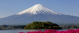
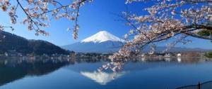
Fujiyama
Or simply Mount Fuji and its volcano of the same name became a symbol of all of Japan many years ago. This is the same ideally shaped conical mountain that is depicted on postcards from the Land of the Rising Wave, on Japanese money and on other things that are in any way connected with this state. The top of Mount Fuji is covered with a layer of snow in winter, but in summer it thaws and every tourist can climb to its top.
You should be prepared for the fact that you will find yourself at an altitude of 3800 meters above sea level and altitude sickness will not bypass you. However, being above the clouds and enjoying the views that open from Fuji is simply necessary - it’s like a fairy tale.
It is believed that this volcano is currently inactive. The last lava eruption was in 1707-1708, since then the mountain has no longer “breathed”. However, not so long ago, Fuji still managed to cover all the towns that are at its foot with volcanic ash.
Exploring the volcanoes of Japan is an interesting activity for the most inquisitive tourists. It is very beautiful and interesting, fascinating and at the same time dangerous. If all these factors are components of an ideal trip for you, then go to the land of the rising sun right now!
Found a violation? Report content
Emergence
Since the territory in which the Japanese islands are located is part of the Pacific Ring of Fire, there are a huge number of both active and extinct fire-breathing mountains. If you look closely at the map of Honshu, you will find that on this island alone there are more than twenty volcanoes (half of them erupted in the past, and some even in this century).
As for Fuji, this mountain is located at the junction of several lithospheric plates: the Philippine, Eurasian and Okhotsk. It did not appear immediately: first Sen-Komitake was formed, and after its collapse - Komitake, but that did not last long.
Eighty thousand years ago, “Old Fuji” appeared in its place, which after 20 thousand years began to exhibit constant volcanic activity that lasted for ten centuries, and as a result the volcano was destroyed.
Instead, 11 thousand years ago, a young volcanic cone, “Young Fuji,” appeared, on the slopes of which more than a hundred lateral clefts subsequently formed . And some time later, the flows of basaltic lava erupted by it blocked the road to the rivers, the sources of which began in the north of Fuji, forming the Five Lakes of Fuji.
Honshu
| Name | Type | Height, m | Coordinates | Last Activity |
| Abu | panel | 641 | 34°30′ N. w. 131°36′ E. long / 34.500° n. w. 131.600° E. d. / 34.500; 131.600 (G) [www.openstreetmap.org/?mlat=34.500&mlon=131.600&zoom=14 (O)] (I) | — |
| Adatara | stratovolcano | 1 718 | 37°38′39″ n. w. 140°17′10″ E. d. / 37.64417° n. w. 140.28611° E. d. / 37.64417; 140.28611 (G) [www.openstreetmap.org/?mlat=37.64417&mlon=140.28611&zoom=14 (O)] (I) | 1996 |
| Azuma | stratovolcano | 2 035 | 37°43′56″ n. w. 140°14′52″ E. long / 37.73222° north w. 140.24778° E. d. / 37.73222; 140.24778 (G) [www.openstreetmap.org/?mlat=37.73222&mlon=140.24778&zoom=14 (O)] (I) | 1977 |
| Akagi | stratovolcano | 1 828 | 36°33′26″ n. w. 139°11′47″ E d. / 36.55722° n. w. 139.19639° E. d. / 36.55722; 139.19639 (G) [www.openstreetmap.org/?mlat=36.55722&mlon=139.19639&zoom=14 (O)] (I) | — |
| Akita-Komagatake | stratovolcano | 1 637 | 39°45′30″ n. w. 140°48′10″ E. d. / 39.75833° n. w. 140.80278° E. d. / 39.75833; 140.80278 (G) [www.openstreetmap.org/?mlat=39.75833&mlon=140.80278&zoom=14 (O)] (I) | 1971 |
| Akita-Yakeyama | stratovolcano | 1 366 | 39°57′40″ n. w. 140°45′38″ E. d. / 39.96111° n. w. 140.76056° E. d. / 39.96111; 140.76056 (G) [www.openstreetmap.org/?mlat=39.96111&mlon=140.76056&zoom=14 (O)] (I) | 1997 |
| Asama | complex | 2 568 | 36°24′12″ n. w. 138°31′34″ E. d. / 36.40333° n. w. 138.52611° E. d. / 36.40333; 138.52611 (G) [www.openstreetmap.org/?mlat=36.40333&mlon=138.52611&zoom=14 (O)] (I) | 2009 |
| Bandai | stratovolcano | 1 819 | 37°35′53″ n. w. 140°04′32″ E. d. / 37.59806° n. w. 140.07556° E. d. / 37.59806; 140.07556 (G) [www.openstreetmap.org/?mlat=37.59806&mlon=140.07556&zoom=14 (O)] (I) | 1888 |
| Iwaki | stratovolcano | 1 625 | 40°39′12″ n. w. 140°18′24″ E. long / 40.65333° north w. 140.30667° E. d. / 40.65333; 140.30667 (G) [www.openstreetmap.org/?mlat=40.65333&mlon=140.30667&zoom=14 (O)] (I) | 1863 |
| Iwate | complex | 2 041 | 39°50′59″ n. w. 141°00′16″ E. d. / 39.84972° n. w. 141.00444° E. d. / 39.84972; 141.00444 (G) [www.openstreetmap.org/?mlat=39.84972&mlon=141.00444&zoom=14 (O)] (I) | 1919 |
| Izu-Tobu | 1 406 | 34°53′59″ n. w. 139°05′52″ E. d. / 34.89972° n. w. 139.09778° E. d. / 34.89972; 139.09778 (G) [www.openstreetmap.org/?mlat=34.89972&mlon=139.09778&zoom=14 (O)] (I) | 1989 | |
| Ontake | 3 067 | 35°35′34″ n. w. 137°48′49″ E long / 35.59278° north w. 137.81361° E. d. / 35.59278; 137.81361 (G) [www.openstreetmap.org/?mlat=35.59278&mlon=137.81361&zoom=14 (O)] (I) | 2014 | |
| Chokai | stratovolcano | 2 233 | 39°05′47″ n. w. 140°03′08″ E. d. / 39.09639° n. w. 140.05222° E. d. / 39.09639; 140.05222 (G) [www.openstreetmap.org/?mlat=39.09639&mlon=140.05222&zoom=14 (O)] (I) | 1974 |
| Fujiyama | stratovolcano | 3 776 | 35°21′27″ n. w. 138°43′50″ E. d. / 35.35750° n. w. 138.73056° E. d. / 35.35750; 138.73056 (G) [www.openstreetmap.org/?mlat=35.35750&mlon=138.73056&zoom=14 (O)] (I) | 1708 |
| Hakkoda | stratovolcano | 1 585 | 40°39′22″ n. w. 140°52′51″ E. d. / 40.65611° n. w. 140.88083° E. d. / 40.65611; 140.88083 (G) [www.openstreetmap.org/?mlat=40.65611&mlon=140.88083&zoom=14 (O)] (I) | —XVII centuries |
| Hakone | complex | 1 438 | 35°13′48″ n. w. 139°01′26″ E. d. / 35.23000° n. w. 139.02389° E. d. / 35.23000; 139.02389 (G) [www.openstreetmap.org/?mlat=35.23000&mlon=139.02389&zoom=14 (O)] (I) | —XIII centuries |
| Hakusan | stratovolcano | 2 702 | 36°09′07″ n. w. 136°46′28″ E. d. / 36.15194° n. w. 136.77444° E. d. / 36.15194; 136.77444 (G) [www.openstreetmap.org/?mlat=36.15194&mlon=136.77444&zoom=14 (O)] (I) | 1659 |
| Haruna | stratovolcano | 1 449 | 36°28′26″ n. w. 138°52′53″ E. long / 36.47389° north w. 138.88139° E. d. / 36.47389; 138.88139 (G) [www.openstreetmap.org/?mlat=36.47389&mlon=138.88139&zoom=14 (O)] (I) | 6th century |
| Hachimantai | stratovolcano | 1 614 | 39°57′18″ n. w. 140°51′27″ E. d. / 39.95500° n. w. 140.85750° E. d. / 39.95500; 140.85750 (G) [www.openstreetmap.org/?mlat=39.95500&mlon=140.85750&zoom=14 (O)] (I) | — |
| Hijiori | caldera | 516 | 38°36′21″ n. w. 140°10′42″ E. d. / 38.60583° n. w. 140.17833° E. d. / 38.60583; 140.17833 (G) [www.openstreetmap.org/?mlat=38.60583&mlon=140.17833&zoom=14 (O)] (I) | — |
| Khiuti | stratovolcano | 2 356 | 36°57′07″ n. w. 139°17′19″ E. d. / 36.95194° n. w. 139.28861° E. d. / 36.95194; 139.28861 (G) [www.openstreetmap.org/?mlat=36.95194&mlon=139.28861&zoom=14 (O)] (I) | 1544 |
Kyushu
| Name | Type | Height, m | Coordinates | Last Activity |
| Aso | caldera | 1 592 | 32°52′51″ n. w. 131°06′23″ E. d. / 32.88083° n. w. 131.10639° E. d. / 32.88083; 131.10639 (G) [www.openstreetmap.org/?mlat=32.88083&mlon=131.10639&zoom=14 (O)] (I) | 2015 |
| volcano. Ibusuki field | calderas | 922 | 31°13′ n. w. 130°34′ E. Longitude / 31.217°N w. 130.567° E. d. / 31.217; 130.567 (G) [www.openstreetmap.org/?mlat=31.217&mlon=130.567&zoom=14 (O)] (I) | 9th century |
| Fukuejima | panel | 317 | 32°39′11″ n. w. 128°51′04″ E. d. / 32.65306° n. w. 128.85111° E. d. / 32.65306; 128.85111 (G) [www.openstreetmap.org/?mlat=32.65306&mlon=128.85111&zoom=14 (O)] (I) | — |