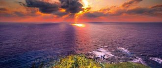
Mount Fuji is included in the list of the main attractions of Japan - the Land of the Rising Sun, which is divided into many islands. To find out where Mount Fuji is located, you need to analyze the geography of Japan.
As mentioned above, Japan is divided into islands, highlight here: Hokkaido, Honshu, Kyushu, Shikoku. The most developed and largest is the island of Honshu. Here is Tokyo, the capital of Japan and the largest metropolis in the world, and 90 kilometers from it is an active stratovolcano called Fuji.
It is now generally accepted that the volcano is weakly active, since its last eruption occurred in 1707–1708. The mountain has inspired many poets and artists since ancient times. However, it still does this today, simultaneously serving as a place of tourism, pilgrimage and an object for photography. Every day, travelers flying into Tokyo visit the volcano, either on their own or as part of a tour.
Mountain name
The name Fujiyama is shrouded in mystery: there is no exact version of the origin of the name, but there are various assumptions. In particular, the story “Taketori Monogatari” mentions that the name of the volcano is a derivative of the word “immortality”, or the phrase “many soldiers”.
Japanese ethnic etymology claims that the name arose from the word “incomparable.” Other sources interpret the name as “inexhaustibility.”
In Edo times, one scientist put forward a version: “Fuji” arose from a word meaning “a mountain standing slenderly...”. Others are of the opinion that the name originated from the phrase “... long slope.”
It should be noted that each of the above versions has its right to exist, but in the works of scientists who have studied this topic, too few weighty arguments are given to accept one or another version as the only correct one.
Mountaineering routes
Mount Fuji in Japan can be conquered if a tourist climbs one of 4 routes along the northern and southern slopes. Routes start at different points and are divided into levels (stations).
There are 10 stations on the slopes of the mountain - this is associated with pilgrimage traditions. At each level there is a column indicating the height. If the tourist purchased a special staff for lifting, then at the station the employee will make a mark on it. It means that a certain part of the path to the sacred peak has been passed.
More details about the routes:
- Yoshida-Guchi (Yoshida-Guchi) has a length of 13.8 km. It starts from station No. 5 at an altitude of 2305 m. The ascent takes 6-7 hours, the descent along a separate road takes 3-4 hours. This route is attractive for unprepared tourists due to the presence of hostels and shops.
- Fujinomiya-guchi, with a length of 8.7 km, although short, is considered difficult. Tourists ascend and descend along the same path, which often causes congestion and slows down progress. The ascent takes 6 hours, the descent 4-5 hours.
- Subashiri-Guchi (Subashiri-Guchi) is the easiest. It starts at 2000 m and has a length of almost 13 km. The ascent will take 7-8 hours, the descent along another path will take 3-4 hours. The route is distinguished by picturesque views.
- Gotemba-guchi (Gotemba-Guchi) is recognized as the longest ; along the 17.4 km route, tourists can expect significant differences in altitude. The ascent usually takes 8-9 hours, the descent 4-4.5 hours. Due to its complexity, the trail is least crowded, but the tourist is required to be physically prepared and have proper equipment.
The trails are equipped with rope railings, platforms and steps.
The routes are marked with signs in Japanese and English, each route is marked with a different color:
- Yoshida – yellow;
- Subashiri – red;
- Fujinomiya - blue;
- Gotemba – green.
Since 2013, climbing the sacred mountain has become paid; the entrance ticket costs $9. Tourists should note that on all routes, toilets must be paid for in cash.
If adaptation to mountain conditions is required, then experienced climbers advise going up to station No. 5, spending the night, and early in the morning going to conquer the peak. After admiring the views, return to the station, spend the night again and then return to the city. Worshipers of the sacred mountain and pilgrims begin their climb at midnight to reach the top by dawn.
A successful trip to the mountain will be if the traveler is properly equipped.
What to take with you:
- Shoes. Be sure to wear mountain boots that are waterproof and well ventilated.
- Cloth. The best option is a quick-drying jacket and pants made of water-repellent fabric, under which you should wear a long-sleeve shirt to avoid sunburn. You will need a warm sweater, because it is cold at the top. A change of shirt, mittens and a bandana will come in handy to wipe away sweat and protect your face from dust.
- The backpack must correspond to the anatomical features. To protect your backpack from rain, you will need a film or rain cover.
- You will definitely need a hat (a warm hat and a cap with a visor), as well as sunglasses.
- A mountain walking stick , headlamp, map, and camera will complete your equipment.
Sirito Falls
The routes to the Japanese mountain have modern infrastructure, there are snack machines and toilets, but experienced travelers recommend taking light, high-calorie snacks with them. This will help not only save money (the higher, the more expensive), but also not depend on the location of the machines. 2 bottles of 0.5-1 liters of water and tea in a thermos will come in handy.
Structure of the volcano
Mount Fuji on the map is located above an extended line along which some earth blocks are submerged under others, which is part of the Pacific Ring of Fire. Fuji is located at the junction of three plates.
This area is marked by centuries of activity and frequent eruptions. Historically, there are several stages of the volcanic process as a result of which Mount Fuji was formed.
- The emergence of andesitic lavas to the surface and the formation of the Sen-Komitake volcano. Later it was replaced by Komitake, a basalt volcano.
- Formation of "Old Fuji".
- The emergence and development of "Young Fuji".
- Frequent volcanic explosions and repeated outpourings of lava over the next millennia. Now, as a result of explosions, magma from the basalt comes to the surface. Numerous craters formed on the slopes.
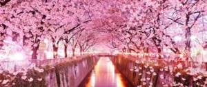
The lava was blocked by rivers originating in the mountains called Misaka. From here came the Fuji Five Lakes, the most popular resort destination in Japan.
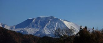
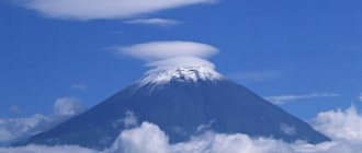
Returning to the history of the volcano, it is necessary to note the largest eruptions of basaltic magma to the surface. They occurred in 800, 864 and 1707–1708. The latter is characterized by incredible force, when a new crater formed in the east of the mountain, resulting in ash emissions that covered some parts of Tokyo. Volcano Fuji has an almost perfect conical shape, which makes it quite aesthetic and pleasing to the eye.
Eruptions
Volcano Fuji, which belongs to the type of volcanoes - dormant, but not extinct. The last time an eruption occurred was in 1707. It was a long, destructive process, provoked by an earthquake that occurred shortly before. Within two weeks, nearby villages were covered in ash. Agricultural lands were damaged, causing the death of the population from starvation. The city of Edo (modern Tokyo) was covered with a 15-centimeter layer of ash.
In total, over the long history of observations (since 718), 12 eruptions of Fuji have been recorded. It is worth special mentioning the following:
- 800 - as a result of volcanic activity, the road connecting Japanese settlements is filled with ash;
- 864 - the mountain erupted for two months. Lava buried nearby villages, and a flow of hot liquid divided Lake Senuomi into two others, smaller in size. The scorched earth could not recover for a long time: the forest at the site of the disaster was restored after a millennium.
More than three hundred years have passed since the last eruption, but Fuji is still dangerous: the mountain can awaken at any moment. Volcanologists tirelessly watch the dormant symbol of the Land of the Rising Sun: sometimes a light smoke appears above the crater, reminding people that the awakening of the monster is a very real prospect.
Five Lakes of Mount Fuji
It is impossible not to mention an important attraction associated with Fuji. These are five lakes that arose at the foot of the mountain. Their height is approximately 1 thousand meters. From here it is most convenient to start climbing the mountain and enjoy the view of the volcano.
The majority of tourists visit the lakes not to climb to the top of the volcano. There are many other entertainment options here. For example, one of the tallest roller coasters in the world (located in an amusement park). The resort itself is attractive with the opportunity to relax and admire the volcano up close.
Where is Fujiyama located?
The volcano is located on one of the islands that belong to Japan. It can be found ninety kilometers from Tokyo. The top of this amazing mountain can be seen from the city streets.
Mount Fuji on the map of Japan
0
Author of the publication
offline 3 years
Nika
18
I am interested in hiking and traveling, photography and videography. I have been going hiking since childhood. The whole family went and went - sometimes to the sea, then to the river, to the lake, to the forest. There was a time when we spent a whole month in the forest. We lived in tents and cooked over fires. This is probably why I am still drawn to the forest and, in general, to nature. I travel regularly. About three trips a year for 10-15 days and many 2 and 3 day hikes.
Comments: 0Publications: 668Registration: 10/23/2018
Nika Travel routes
General characteristics of the lakes of Mount Fuji
The lake group consists of Yamanaka, Kawaguchi, Sai, Shoji and Motosu. Each has distinctive features: for example, Lake Kawaguchi is the largest, Shoji is the smallest, Yamanaka has a high water level, and Motosu has depth. They are fresh.
The Five was formed in ancient times: about 50-60 thousand years ago as a result of huge lava flows that solidified and formed boundaries that fenced off the waters of local rivers. However, Motosu, Shoji and Sai are connected to each other through underground drains.
One of the reasons to visit here
Undoubtedly, Fuji is one of the most beautiful natural creations of our planet. However, this is not the only thing that brought her such fame. In the minds of the Japanese, Fuji is very far from its real image. Even an educated person is sure that the souls of the enlightened live in the depths of the volcano.
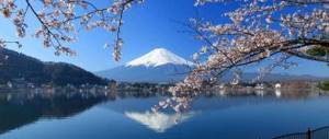
Mount Fuji and Lake Kawaguchi-ko in the summer season
The history of the mountain is shrouded in many secrets, myths and legends. At its top there are mysterious sanctuaries, and at the base grows the no less mysterious “Forest of Suicides”. Only after visiting these places will you be able to understand what the Fuji phenomenon is and separate truth from fiction.
The image of a volcano in Japanese and international culture
On canvases and in descriptions of poets, Mount Fuji appears covered with ice and has a sharp peak. In ancient times, it was believed that the smoke coming from it was the product of the elixir of immortality lit in the depths of the mountains, and the one who conquered Mount Fuji would receive its secret and gain eternal life.
However, cultural scientists and Japanese studies note that the poetic image of a volcano and the real one have significant differences. This is explained by the fact that the artists of the Edo period did not set themselves the goal of reproducing a realistic image of Fuji - they showed its beauty and aesthetics, but that’s all.
In addition, Fuji does not have eternal ice - in late summer there is no snow on the tops of the mountain, and its slopes are depicted as sharp, inaccessible, steep, which can only be conquered by God's chosen one (in reality this is far from the case, as evidenced by regular excursions and trips to the mountain).
Few foreigners know that at the top of the volcano there is a Shinto shrine and other buildings that are sacred to Shinto. The territory of Mount Fuji is in his possession.
In addition to Shinto buildings, there is a post office and a weather station on site. At the top there is an active life: both religious and scientific, which is very typical for the Japanese.
Data
- Dimensions and location: Fuji, or Fuji-san, has a height of 3776 m and is located on the island of Honshu, 100 km from Tokyo.
- Status: Considered an active volcano with a limited likelihood of eruption.
- History: Fuji was formed about 100,000 years ago, finally forming 10,000 years ago.
- First ascent: An unknown monk climbed to the top in 663.
- Eruptions: Since 781, 6 eruptions have been recorded, the last one lasting from November 24, 1707 to January 22, 1708.
Share link
Climbing
During the summer seasons, there is a rescue service and hospitable “huts” on the slopes - cafes where you can buy food, drinks and even sleep. The summer months are the most favorable months for conquering the peak, as long as there are no snow deposits. Foreigners arriving in Tokyo often have questions about where Mount Fuji is and how to get to it, but this problem is solved quite quickly, since there are a great many paths leading from the capital of Japan to the foot of the mountain!
Geographically, the mountain is divided into 10 levels. From the fifth level there are four paths leading up. Any of the routes takes 3–8 hours without rest, the descent takes 2–5 hours.
In addition to tourist routes, there are paths intended for bulldozers that deliver food and other materials to the mountain huts and souvenir shops located on the top of the mountain. But bulldozers are also designed to evacuate people in trouble and in need of medical care. For tourists, such routes are a huge danger, since they do not provide special protection from the stones that regularly fall from the top of the mountain. But on such roads you can often meet cyclists who prefer to climb by other routes at their own peril and risk.
Climatic conditions
Due to the high altitude of the peak, there are different climate types along its slopes. Much of the mountain has an alpine climate , characterized by cold temperatures and strong winds blowing from west to northwest. Due to severe turbulence, a Boeing 707 911 crashed into a mountain on March 5, 1966, killing 124 people on board.
The summit is only snow-free for a short period during the summer months, although sudden snowfalls can occur even during the hottest time of the year.
Tourism
Without a doubt, Fuji is a volcano that is the most popular and main tourist attraction in Japan. It is not surprising that most residents of the country consider it the most beautiful place on the entire planet. Starting in July, for three months, local rescue centers and small mountain huts are at the disposal of tired tourists and travelers. Trading of food and drinks is also very common here during this time.
Of the three trails to the summit, one main one has been identified. There are ten points intended for recreation. Here, each conqueror of the peak is given special staffs made of bamboo. They significantly help them when climbing. Moreover, at each of the stations a mark is applied to the staffs, which confirms that the tourist has actually overcome the stage. To simplify the ascent, a road has been built up to half the way (to the fifth point).
Part of the national park
As noted above, Mount Fuji is an integral part of the national park. On its slopes you can find many signs warning about a strict ban on throwing garbage. Moreover, before the ascent, each pilgrim receives a package intended for his collection, if one was left by someone. At the same time, no one considers it shameful to contribute to maintaining the Japanese shrine in a clean condition. To ensure proper order, there are also many automatic dry closets on the slopes.
World fame
In June 2013, Fuji was included in the UNESCO list. It is noteworthy that it was included in this respectable list not as an interesting natural phenomenon, but as an object of cultural heritage. This is a tribute to the fact that for many centuries the volcano has inspired artists and poets to create. Therefore, officially the UNESCO list includes: “Mount Fuji. An inexhaustible source of inspiration and an object of religious worship." In addition, the volcano and its surroundings are part of the Fuji-Hakone-Izu National Nature Park. And the five lakes - Sai, Shojin, Motosu, Yamanaka and Kawaguchi - are a resort where Tokyo residents like to relax.